You are reading: drone rules for the Netherlands
Drone rules Netherlands · Updated 2026
Flying a drone in the Netherlands: what visitors need to know in 2026
The Netherlands applies the EU drone regulation, so an operator registration and pilot certificate from any EU country are valid. Airspace is where it gets tight. A long list of areas is closed to the open category – from airports and ports to railways, fast roads and low-flying routes where 30 m is the limit. Flying over the Wadden Sea is banned, and so it is over some Natura 2000 sites. New from 26 November 2026: around five civil airports you may fly in zone 3 without contacting air traffic control.
- EU registration valid
- Many no-fly zones
- New CTR rules from 26 Nov 2026
Visitor checklist No-fly zones
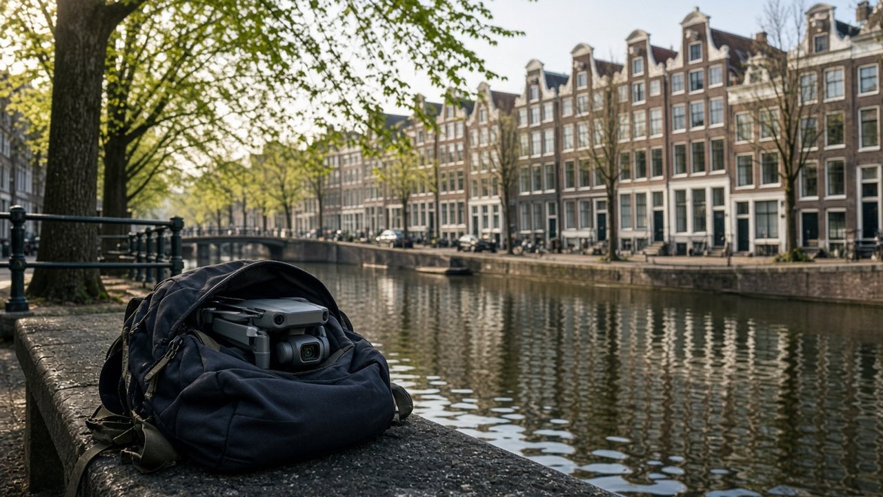
AI-generated image
Status: legal position in 2026, based on Regulation (EU) 2019/947, the Dutch government’s information pages (Rijksoverheid, Veilig drone vliegen), the Regeling zonering onbemande luchtvaartuigen in the version applying from 26 November 2026, the Besluit beperkingen burgerluchtverkeer Waddenzee and information from the RDW. Editorial guidance, not legal advice.
120 m
maximum height
30 m
in low-flying routes
450 m
no-fly ceiling over the Wadden Sea
26 Nov 2026
new zones at five airports
20 kg
insurance required from here
The Netherlands is small, densely populated and full of restricted zones. If you want to take off on a dyke, beach or canal on the spur of the moment, check GoDrone first [4]. Separately, EASA proposed in September 2026 that registration and Remote ID should start at 100 g – not law yet [17].
The key points in 20 seconds
Operators register only in their country of residence; your home registration applies in the Netherlands [1], [2].
A1/A3 proof of training and A2 certificates from any EU country are accepted [1], [2].
Not over government buildings, military sites, events, railways, roads with a limit of 80 km/h or more, ports and airport areas [4], [8].
Only A1 with C0/C1 or A2 with C2 and no higher than 30 m; A3 flights are banned [4], [8].
EU law and Dutch rules: what applies where?
The Netherlands applies Implementing Regulation (EU) 2019/947 with the open, specific and certified categories, a 120 m height limit and visual line of sight [1], [3]. Operators register in the EU country where they live [2]. The Dutch RDW registers people listed in the Dutch population register (BRP) and has a separate procedure for those living abroad. With a registration from another EU country you need neither [2], [11].
What sets the Netherlands apart is its geographical zones. The Regeling zonering onbemande luchtvaartuigen closes uncontrolled aerodromes and hospital helipads, ports, industrial sites and more than a hundred locations with vital infrastructure to the open category; in low-flying routes the limit is 30 m [8]. The government sums this up in a list of areas you may not fly over in the open category [4].
| Topic | Rule in the Netherlands | Basis |
|---|---|---|
| Operator | EU registration in your country of residence is valid | EU 2019/947, EASA |
| Remote pilot | A1/A3 or A2 from any EU country | EU 2019/947 |
| Height | Up to 120 m, up to 30 m in low-flying routes | EU 2019/947, Regeling zonering |
| Civil airport control zones | From 26 Nov 2026: zone 3 open to the open category, zones 1, 2A and 2B closed | Regeling zonering Art. 3a |
| Military airport control zones | Fully closed to the open category | Regeling zonering Art. 3b |
| Wadden Sea | Flight ban up to 450 m | Besluit Waddenzee |
| Natura 2000 | Banned at some sites; the province or site manager decides | Rijksoverheid |
| Insurance | Required for private users from 20 kg | RDW, EU law |
Sources: Rijksoverheid and Veilig drone vliegen [3], [4], [5], Regeling zonering [8], Besluit Waddenzee [9], RDW [11], [13].
Visiting the Netherlands with a drone: your checklist
The good news: you need no extra registration and no account on a Dutch portal. The effort goes into checking the zone before every take-off [4].
Your operator number from home is valid in the Netherlands and must be visible on every drone [1], [2].
Carry your A1/A3 proof or A2 certificate on paper or on your phone [1], [12].
GoDrone and the Aeret Kaartviewer show zones and restrictions [4].
From 26 Nov 2026, only zone 3 is open to the open category at five civil airports; military control zones stay closed [7], [8].
Your operator number must be visible on every drone. One option is a 20 × 8 mm aluminium plate, laser-engraved with your operator number without the three secret characters. According to the seller it is made for light drones such as the DJI Mini series or Neo.

Control zones: what changes on 26 November 2026
Around airports, a control zone (CTR) extends roughly 15 km. Until now, drone pilots always had to contact air traffic control there [7]. In the open category, flying in a CTR is mostly not allowed [5].
From 26 November 2026, the control zones of Schiphol, Lelystad, Groningen-Eelde, Maastricht and Rotterdam are divided into zones 1, 2A, 2B, 3 and 4. The open category is banned in zones 1, 2A and 2B [8]. In zone 3 you need neither notification nor clearance from air traffic control; if you lose control of the drone there, you call the police [8], [16]. Zone 4 starts above 120 m and is therefore off limits to the open category anyway [16].
Eindhoven, Gilze-Rijen, Leeuwarden, Volkel, Woensdrecht, Deelen, De Peel and De Kooy remain fully closed to the open category [8].
Helipads and vital facilities inside and outside the new areas do not change [7].
The new layout also applies outside the airports’ opening hours [16].
GoDrone shows the boundaries; the government points to GoDrone and the Aeret Kaartviewer [4].
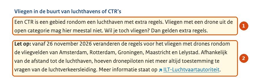
- In a CTR, an open-category drone is mostly not allowed to fly.
- From 26 November 2026 the rules change around Amsterdam, Rotterdam, Groningen, Maastricht and Lelystad; depending on the distance to the airport, permission from air traffic control is no longer always needed.
Source: Ministry of Infrastructure and Water Management, veiligdronevliegen.nl · screenshot taken 18 Nov 2026 · markings: drohnen.de
No-fly zones, low-flying routes and Natura 2000
| Area | Rule | Basis |
|---|---|---|
| Government buildings, military and secured sites | No overflight | Veilig drone vliegen, Regeling zonering Art. 6 |
| Events, cordoned-off areas, emergency operations | No overflight | Veilig drone vliegen |
| Roads from 80 km/h, railways, power lines | No overflight | Veilig drone vliegen |
| Large seaports and industry | Closed to the open category | Regeling zonering Art. 4, 5 |
| Small aerodromes, hospital helipads | Circles of 1,200 m or 3,000 m closed | Regeling zonering Art. 3 |
| Low-flying routes and areas | Max. 30 m, only A1 with C0/C1 or A2 with C2; A3 banned | Regeling zonering Art. 2 |
| Wadden Sea | Motorised air traffic banned up to 450 m | Besluit Waddenzee |
| Some Natura 2000 sites | The province or site manager decides | Veilig drone vliegen |
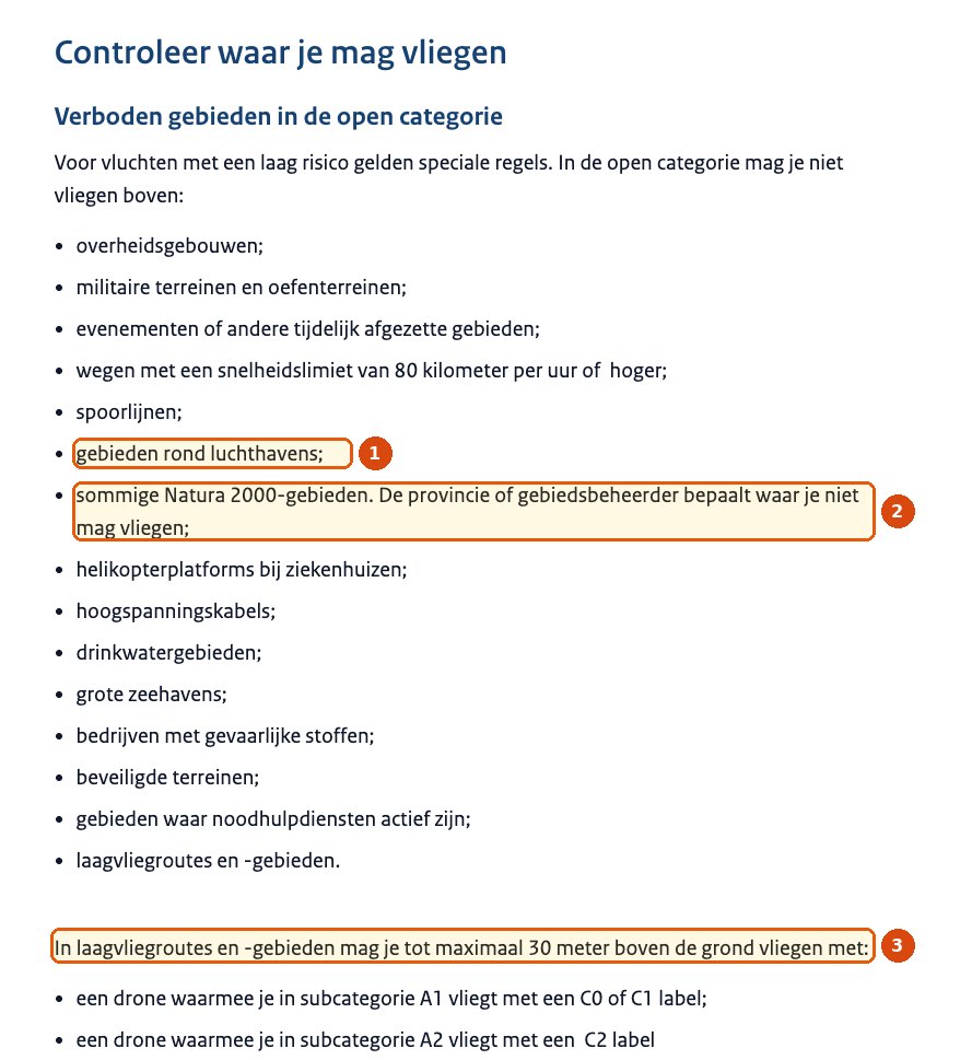
- Areas around airports.
- Some Natura 2000 sites – the province or site manager decides where you may not fly.
- In low-flying routes and areas, no higher than 30 m above ground, only with C0/C1 in A1 or C2 in A2.
Source: Ministry of Infrastructure and Water Management, veiligdronevliegen.nl · screenshot taken 18 Nov 2026 · markings: drohnen.de
Wadden Sea: Civil air traffic with motorised aircraft is banned up to 450 m above ground or water over the Wadden Sea environmental protection area [9]. In a 2024 consultation, the ministry confirmed that drones may not fly there; the exceptions under discussion only cover rescue, enforcement, inspection, measurements and news coverage [10].
Natura 2000: Whether you may fly over a protected site is decided by the province or the site manager [4]. In Dwingelderveld National Park, for example, flying without a permit is banned under the Environment and Planning Act (Omgevingswet) and the Natura 2000 management plans; the landowner, such as Staatsbosbeheer, may also have its own rules [14].
Insurance
For private users, insurance is only mandatory from 20 kg, based on EU law [13].
The RDW strongly advises covering injury and property damage to third parties and checking whether your liability policy covers drones [13].
Check whether your liability insurance covers drone damage in the Netherlands.
Common mistakes on a Dutch holiday
Low-flying routes allow 30 m at most, and no A3 flights at all [8].
From 26 Nov 2026 only zone 3 is open; zones 1, 2A and 2B stay closed to the open category [8].
Drones are not allowed over the World Heritage site without a permit [15].
The Netherlands from above: canals, windmills and tidal flats
The best-known sights of the Netherlands lie close together: Amsterdam’s 17th-century canal ring [18], the mill network at Kinderdijk-Elshout [19], tulip fields in spring and the Wadden Sea, a World Heritage site shared with Germany and Denmark [20].
For drone pilots, the country is tightly regulated: airports, port areas, railways, fast roads, Natura 2000 sites and low-flying routes often lie side by side [8]. Before every take-off, the map decides – not the view.
Places worth seeing – and what to check
AmsterdamCanal ring
A half-ring of canals and gabled houses around the old town, World Heritage since 2010 [18].
Drone check: Busy city centre near Schiphol: check the zone in GoDrone, keep your distance from people and never fly over crowds.
South HollandKinderdijk
Windmills, dykes and pumping stations showing Dutch water management [19].
Drone check: Drones are not allowed over the World Heritage site without a permit [15].
North SeaWadden Sea and Texel
Tidal flats, islands and dunes – World Heritage [20].
Drone check: Civil flights with motorised aircraft are banned up to 450 m over the Wadden Sea environmental protection area [9].
RotterdamPort and skyline
Modern architecture and one of Europe’s largest ports.
Drone check: Large parts of the port area are closed to the open category, and Rotterdam also has a control zone [8].
Where the drone stays on the ground
Civil air traffic with motorised aircraft is banned up to 450 m above ground or water over the environmental protection area [9]. Texel’s tourist board says drone photo and video flights are not allowed there [21].
The World Heritage site lies in a Natura 2000 area, and many windmills are homes. No drone without a permit; according to Kinderdijk, anyone causing a nuisance risks a €410 fine [15].
Westpoort in Amsterdam, the port of Rotterdam, Moerdijk, Vlissingen and other port areas are closed to the open category [8].
Videos: EU rules and the Netherlands from above
The first video is from our own YouTube channel and in German; turn on subtitles and choose “Auto-translate” for English. Channel names, dates and running times are taken from the YouTube pages. We cannot verify whether the landscape and travel films contain aerial shots taken with permission, and they do not show where you may fly today.
EU Drohnenverordnung – Änderungen ab 2024 für alle Drohnen und Drohnenklassen
Our own explainer on the end of the EU transition period on 1 January 2024: legacy drones under and over 250 g, classes C0, C1 and C2, and why registration and certificates are valid across the EU. Dutch zones and the new CTR rules are not covered.
The video only loads from YouTube after you click (privacy-enhanced mode). Watch on YouTube
The Netherlands 4K – Scenic Relaxation Film With Calming Music
A calm landscape film of cities, canals, windmills and tulip fields set to music, without narration. The film does not say where or with which permission the footage was shot.
The video only loads from YouTube after you click (privacy-enhanced mode). Watch on YouTube
Visiting Kinderdijk: Exploring The Historic Windmills [4K]
A travel video with tips for visiting Kinderdijk. Worth knowing as a drone pilot: drones are not allowed over the World Heritage site without a permit.
The video only loads from YouTube after you click (privacy-enhanced mode). Watch on YouTube
Frequently asked questions about drones in the Netherlands
Can I bring my drone to the Netherlands?
Yes. With your EU registration and certificate you may fly, provided you avoid the closed zones and follow the EU rules for the open category.
Do I have to register in the Netherlands?
Not if you are registered in another EU country. That registration is valid across the EU; a second one with the RDW is not needed.
Which map is official?
The government names GoDrone and the Aeret Kaartviewer as official maps and tools.
Can I fly in Amsterdam?
The authorities name no general ban over cities. But Schiphol’s control zone applies around the airport, and bans cover events, railways, ports and government buildings. Check your take-off point in GoDrone.
What changes on 26 November 2026?
The control zones of Schiphol, Lelystad, Groningen-Eelde, Maastricht and Rotterdam are divided into zones. In zone 3 you may fly in the open category without air traffic control; in zones 1, 2A and 2B you may not.
Can I fly over the Wadden Sea or on Texel?
Not over the Wadden Sea environmental protection area: motorised civil air traffic is banned up to 450 m. Texel’s tourist board says drone flights are not allowed on the island.
Can I fly at Kinderdijk?
Not without a permit. Kinderdijk lies in a Natura 2000 area; according to the site, only professional pilots may apply for a permit, on strict conditions.
Do I need insurance?
For private users it is only mandatory from 20 kg. The RDW still strongly recommends it.
Where can I get binding information?
From the government at veiligdronevliegen.nl, from the RDW on registration and pilot certificates, and from the ILT on the specific category.
Conclusion: your papers are enough – the map decides
For EU visitors, the Netherlands is formally simple: your registration and certificate are enough, and there is no second registration. The difficulty is the density of restricted zones – from the Wadden Sea and low-flying routes to ports, railways and airports.
If you check every take-off point in GoDrone, skip Kinderdijk and the Wadden Sea and know the new zones around the big airports, you can still find legal spots – away from towns and protected areas, for example.
Share
Who is taking a drone to the Netherlands?
Send this guide to anyone planning to fly in Holland.
TransparencySources and dataprimary sources first
- EUR-Lex: Implementing Regulation (EU) 2019/947 (legal text), accessed 18 Nov 2026.
- EASA: Travelling with drones (EU agency), accessed 18 Nov 2026.
- Rijksoverheid: Regels voor vliegen met drones (government, Dutch), accessed 18 Nov 2026.
- Ministerie van Infrastructuur en Waterstaat – Veilig drone vliegen: Waar kan ik vliegen? (government, Dutch), accessed 18 Nov 2026.
- Ministerie van Infrastructuur en Waterstaat – Veilig drone vliegen: Je vlucht voorbereiden (government, Dutch), accessed 18 Nov 2026.
- Ministerie van Infrastructuur en Waterstaat – Veilig drone vliegen: Welke regels gelden voor iedereen? (government, Dutch), accessed 18 Nov 2026.
- Rijksoverheid: Slimmere indeling van luchtruim rond vliegvelden schept meer ruimte voor veilig vliegen met drones (government, Dutch), 24.09.2026, accessed 18 Nov 2026.
- wetten.overheid.nl: Regeling zonering onbemande luchtvaartuigen (version from 26 Nov 2026, Art. 2–6) (legal text, Dutch), accessed 18 Nov 2026.
- wetten.overheid.nl: Besluit beperkingen burgerluchtverkeer Waddenzee, art. 2 (legal text, Dutch), accessed 18 Nov 2026.
- Overheid.nl – internetconsultatie: Waddenzee zonering onbemande luchtvaartuigen (consultation, Dutch), accessed 18 Nov 2026.
- RDW: Exploitantnummer aanvragen (registreren) (authority, Dutch), accessed 18 Nov 2026.
- RDW: Vliegbewijs aanvragen (authority, Dutch), accessed 18 Nov 2026.
- RDW: Verzekeringen en vluchtvergunningen (authority, Dutch), accessed 18 Nov 2026.
- Nationaal Park Dwingelderveld: Drones in NP Dwingelderveld (national park, Dutch), accessed 18 Nov 2026.
- Kinderdijk: Frequently Asked Questions – May I fly a drone at Kinderdijk? (World Heritage site), accessed 18 Nov 2026.
- Dronewatch: Nieuwe CTR-zonering toegelicht: dit verandert er op 26 november voor drone-operators (trade media, Dutch), 05.11.2026, accessed 18 Nov 2026.
- EASA: Opinion No 06/2026 (EU agency), 18.09.2026, proposal without legal effect.
- UNESCO: Seventeenth-Century Canal Ring Area of Amsterdam inside the Singelgracht (World Heritage listing), accessed 18 Nov 2026.
- UNESCO: Mill Network at Kinderdijk-Elshout (World Heritage listing), accessed 18 Nov 2026.
- UNESCO: Wadden Sea (World Heritage listing), accessed 18 Nov 2026.
- VVV Texel: Regulations for drones on Texel (protected-area management), accessed 18 Nov 2026.
NotesDisclaimer and transparency
Note: This article provides general information on drone law in the Netherlands. It does not replace legal advice or binding information from the Dutch authorities, air navigation service provider LVNL or your insurer. Check the authorities’ information and the official maps before every flight. Last editorial review: 18 November 2026.
Transparency: This article was researched and written with AI assistance and checked by our editors. All photos are AI-generated illustrations; they do not imply permission to fly at the places shown. The screenshots come from veiligdronevliegen.nl; the markings were added by us. The Amazon link is an affiliate link: if you buy through it, drohnen.de earns a commission. Your price does not change, and Amazon takes you to your local store.
Uncertainties: The new CTR zones only apply from 26 Nov 2026; until then, the open category is mostly not allowed in control zones. We have not mapped the exact course of zones 1 to 4 – GoDrone is authoritative. Details on zone 4 and on round-the-clock validity come from Dronewatch’s report on an information session held by the ministry, LVNL and ILT. Whether your specific Natura 2000 site is closed is decided by the province concerned.
Transparency and editorial note: in line with the transparency requirements of Article 50 of the EU AI Act, which apply since 2 August 2026, our articles are checked, put into context and approved by our editors before publication. Final assessment and editorial responsibility rest with our editorial team.
Besides our own and supplied photos, we use illustrative images. These may be created or edited with digital tools. Where legal transparency or labelling duties apply to individual content, it is marked accordingly.

